UNVEILING INNOVATIONS THAT SHAPE THE FUTURE OF WATER MANAGEMENT IN EASTERN NEBRASKA
Projects
Explore datasets, hydrogeologic interpretations and reports for effective water management in Eastern Nebraska
ENWRA’s project listings showcase a dynamic range of initiatives, from pioneering geologic frameworks to cutting-edge interpretations for understanding groundwater-surface water interactions and water budgets. These endeavors, meticulously crafted by collaborating with key partners and employing innovative technologies, represent our commitment to navigating the complex hydrogeologic landscapes of Eastern Nebraska. Dive into the details of each project, uncovering a transformative picture of the subsurface laying the groundwork for a resilient and sustainable water future for the region.
2018 Airborne Electromagnetic (AEM) Surveys
AEM Report Summary Report on “Airborne Electromagnetic Mapping and Hydrogeologic Framework of Selected Regions of the Eastern Nebraska Water Resources Assessment Area” Chapters Completed for Lewis and Clark, Lower Elkhorn, Lower Platte North, Lower Platte South, Nemaha, and Papio-Missouri River Natural Resources Districts. Jared D. Abraham, P.G., Theodore H. Asch, P.G., James Cannia, P.G. and Tammi L. Renninger, Elephant Fish, LLC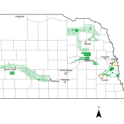
2016 Airborne Electromagnetic (AEM) Surveys
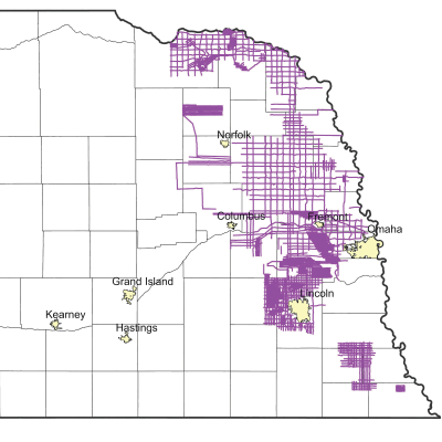
AEM Report Several Natural Resources Districts (NRDs) across the state conducted AEM flights in July and early August 2016 using Water Sustainability Fund (WSF) grant dollars awarded in April 2016: Lewis and Clark NRD, Lower Elkhorn NRD, Papio-Missouri River NRD, Lower Platte North NRD, Lower Platte South NRD, Central Platte NRD, Twin Platte NRD, Lower Loup NRD & the BAZILE AREA (Lewis and Clark, Lower Elkhorn, Upper Elkhorn, Lower Niobrara NRDs). Each NRD had a mix of the following types of surveys flown: block flights (tightly spaced flight lines for determining aquifer boundaries and/or potential groundwater volumes), transect/tie line flights (longer reconnaissance type flight lines), and grid flights (hybrid of reconnaissance and detailed type surveys, aquifer boundary mapping).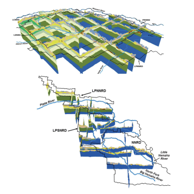
2014/2015 ENWRA Reconnaissance Surveys
AEM Report ENWRA's Reconnaissance AEM Survey effort was broken into two phases: approximately 750 line-miles in the north part of eastern Nebraska flown in October 2014 and 550 line-miles in the south part flown in April 2015. Interpretation of the approximately 1,300 line-miles of AEM data collected in 2014/2015 with the SkyTEM508 system provided a subsurface characterization of the various geologic materials that correlated with pre-existing geologic information. The AEM provided detailed verification and quantification of the geology that underlies the project area. The interpretation also provided a new understanding of the glacial and bedrock features present in the subsurface.Lithologic descriptions from test holes and other supporting down-hole geologic and geophysical information from the University of Nebraska Conservation and Survey Division(CSD) provided the most useful historical information in the development of the new hydrogeologic framework.
2014 Lower Elkhorn Airborne Electromagnetic (AEM) Survey
AEM Report Airborne Electromagnetic Geophysical Surveys and Hydrogeologic Framework Development for Selected Sites in the Lower Elkhorn Natural Resources District, Northeastern Nebraska. These 2014 surveys were tailored to the LENRD's groundwater management goals and provided the initial paths for building out the District's and ENWRA's regional framework.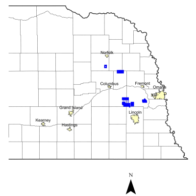
2012 to 2013 Airborne Electromagnetic (AEM) Surveys
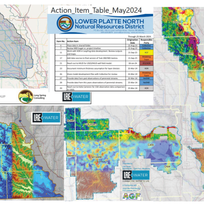
AEM Report The Lower Platte South and Lower Elkhorn NRDs conducted AEM flights in Summer 2013 using the Time Domain Electromagnetic Survey system (Dwight-Valparaiso-Brainard and Clarkson-Howells block flights, respectively). The U.S. Army Core of Engineers also flew a block survey in the Lower Platte North NRD in 2012 and a public entity conducted an AEM reconnaissance survey in Madison County Nebraska in summer of 2013.
2006 to 2009 ENWRA Projects and Reports
AEM Report Explore the older ENWRA Projects and Reports including the initial Introduction to a Hydrogeological Study publication as well as CSD and USGS AEM survey publications for the ENWRA pilot study sites Oakland Ashland and Firth (includes associated Google Earth datasets delivered by AGF in 2016)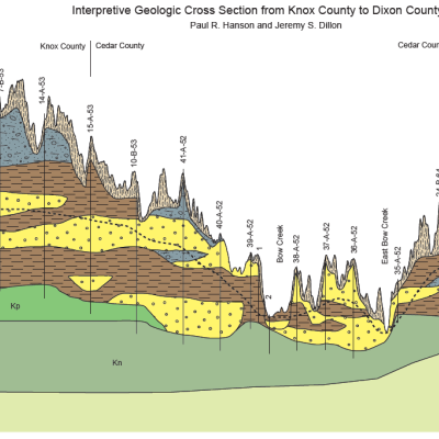
Geologic Cross Sections, Eastern Nebraska
Other This document presents three regional geologic cross sections and accompanying text describing the methodology used to draw the cross sections. Three cross sections were constructed in 2012 (based off older CSD drafts by Vince Dreeszen) across portions of eastern Nebraska to characterize the regional geology of unconsolidated Quaternary deposits and the bedrock units that lie directly beneath them.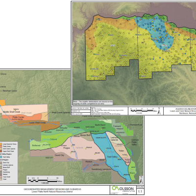
LCNRD and LPNNRD - Delineation Maps
Other PDF map deliverables 2009 to 2011 (1 to 57MB) show a variety of spatial delineations for the Lewis and Clark NRD and the Lower Platte North NRD including the distribution of unconsolidated sand and gravel units serving as localized aquifers at the NRD scale.