2016 Airborne Electromagnetic (AEM) Surveys
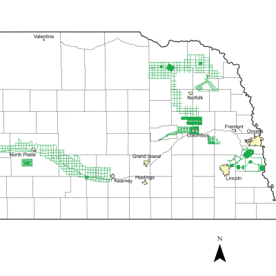
Several Natural Resources Districts (NRDs) across the state conducted AEM flights in July and early August 2016 using Water Sustainability Fund (WSF) grant dollars awarded in April 2016: Lewis and Clark NRD, Lower Elkhorn NRD, Papio-Missouri River NRD, Lower Platte North NRD, Lower Platte South NRD, Central Platte NRD, Twin Platte NRD, Lower Loup NRD & the BAZILE AREA (Lewis and Clark, Lower Elkhorn, Upper Elkhorn, Lower Niobrara NRDs). Each NRD had a mix of the following types of surveys flown: block flights (tightly spaced flight lines for determining aquifer boundaries and/or potential groundwater volumes), transect/tie line flights (longer reconnaissance type flight lines), and grid flights (hybrid of reconnaissance and detailed type surveys, aquifer boundary mapping).
ENWRA often works with various cooperating agencies and partners across the state who have similar hydrogeologic assessment goals. The majority of the NRDs who flew AEM surveys in 2016 also formed a cooperative agreement with Water Sustainability Fund (WSF) grant dollars ("https://nrc.nebraska.gov/water-sustainability-fund-0") to build and support the Nebraska GeoCloud, a data storage and visualization platform for interactive mapping, custom profiles, and data access for AEM, CSD test holes, wells, and related geological models of Nebraska.
Lewis and Clark 2016 AEM Survey (See 2018 AEM for updated 2016 data)
Links
Google Earth Datasets:
The interpreted results for the 2016 AEM flights have been provided in Google Earth format. You can download the free version of Google Earth Pro by clicking here. Click here for a link to download the Google Earth datasets (.kmz file and 58 associated image files, 31 MB) from ENWRA's Dropbox. You do not need to sign-up for a Dropbox account to download the files (download button sometimes hard to spot). You must have Google Earth installed on your computer before downloading or opening the .kmz Google Earth dataset files. If you already have a Dropbox account, please logout and choose download so you do not fill up space on your personal Dropbox.
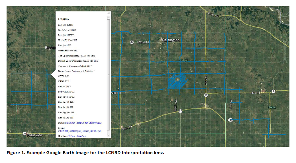
Please follow the instructions in the "GoogleE_README.pdf" PDF file on Dropbox here and save the downloaded files with the same exact file structure as shown on the Dropbox. Google Earth will look here on your hard drive: C:\LCNRD_Prof\ for every profile image when you touch a link on a data dot - see example image below. An easy way is to do this is to create a folder named "LCNRD_Prof" directly on your C drive, download and unzip the Dropbox files wherever your browser typically puts downloaded files, and then save all the downloaded, unzipped files to that LCNRD_Prof folder. NOTE: the 2016 AEM lines were redelivered in the LCNRD 2018 AEM Survey Reporting and should be saved as C:\LCNRD_Profiles.
 Google Earth Tips and Tricks: Grab the map with your cursor and hold down the "u" key on your keyboard to view the earth looking straight down instead of at an angle. Do the same and hit the "n" key to orient the map north as up. Google Earth Pro (link above) is free and you can hit the file menu, then hit open, and then select all data import formats from the dropdown and open an ESRI shapefile or many other GIS file types in Google Earth directly from a saved location on your computer.
Lower Elkhorn NRD 2016 AEM Survey
Links
Google Earth Datasets:
The interpreted results for the 2016 AEM flights have been provided in Google Earth format. You can download the free version of Google Earth Pro by clicking here. Click here for a link to download the Google Earth datasets (.kmz file and 128 associated image files, 74 MB) from ENWRA's Dropbox. You do not need to sign-up for a Dropbox account to download the files (download button sometimes hard to spot). You must have Google Earth installed on your computer before downloading or opening the .kmz Google Earth dataset files. If you already have a Dropbox account, please logout and choose download so you do not fill up space on your personal Dropbox.
Please follow the instructions in the "GoogleE_README_LENRD.pdf" PDF file on Dropbox here AND save the downloaded files with the same exact file structure as shown on the Dropbox. Google Earth will look here on your hard drive: C:\LENRD_Prof\ for every profile image when you touch a link on a data dot - see example image below. An easy way is to do this is to create a folder named "LENRD_Prof" directly on your C drive, download and unzip the Dropbox files wherever your browser typically puts downloaded files, and then save all the downloaded, unzipped files to that LENRD_Prof folder.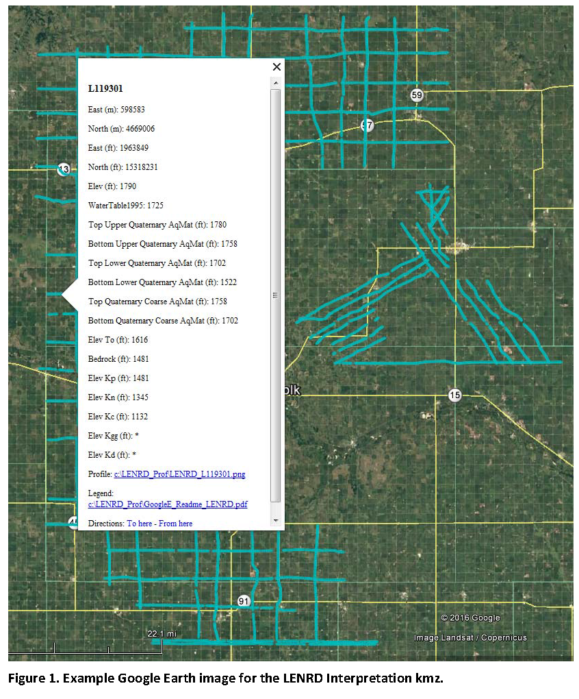
Google Earth Tips and Tricks: Grab the map with your cursor and hold down the "u" key on your keyboard to view the earth looking straight down instead of at an angle. Do the same and hit the "n" key to orient the map north as up. Google Earth Pro (link above) is free and you can hit the file menu, then hit open, and then select all data import formats from the dropdown and open an ESRI shapefile or many other GIS file types in Google Earth directly from a saved location on your computer.
Lower Loup NRD 2016 AEM Survey
Links
Google Earth Datasets:
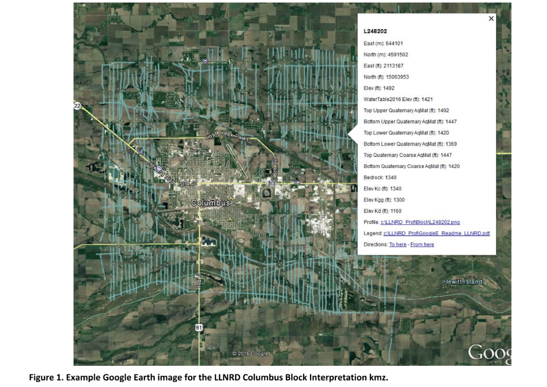
The interpreted results for the 2016 AEM flights have been provided in Google Earth format. You can download the free version of Google Earth Pro by clicking here. Click here for a link to download the Google Earth datasets (54 MB: recon .kmz file with 40 images and Columbus.kmz file with 76 images) from ENWRA's Dropbox. You do not need to sign-up for a Dropbox account to download the files (if you already have a Dropbox account, please logout and choose download so you do not fill up space on your personal Dropbox, button can be hard to spot). You must have Google Earth installed on your computer before downloading or opening the .kmz Google Earth dataset files.
Please follow the instructions in the GoogleE_README_LLNRD.pdf Legend file on Dropbox here AND save the downloaded files with the same exact file structure as shown on the Dropbox (including the main folder entitled LLNRD_Prof). Google Earth will look here on your hard drive: C:\LLNRD_Prof\ for every profile image when you touch a link on a data dot in Google Earth - see example image below. The files on your C drive must all be unzipped in order to work from Google Earth. For example: you can create a folder called "LLNRD_Prof" directly on your C drive, unzip the files wherever your browser typically saves downloaded files, and then save the unzipped downloaded files to that LLNRD_Prof folder on your C.
Google Earth Tips and Tricks: Grab the map with your cursor and hold down the "u" key on your keyboard to view the earth looking straight down instead of at an angle. Do the same and hit the "n" key to orient the map north as up. Google Earth Pro (link above) is free and you can hit the file menu, then hit open, and then select all data import formats from the dropdown and open an ESRI shapefile or many other GIS file types in Google Earth directly from a saved location on your computer.
Lower Platte North NRD 2016 AEM Surveys (see 2018 AEM for updated 2016 data)
Links
Google Earth Datasets: UPDATED KMZ files- See 2018 AEM web page
The interpreted results for the 2016 AEM flights have been provided in Google Earth format. You can download the free version of Google Earth Pro by clicking here. Click here for a link to download the Google Earth datasets (two ".kmz" files and 96 associated image files, 30 for SQS1 and 66 for SQS2, totalling 132 MB) from ENWRA's Dropbox. You do not need to sign-up for a Dropbox account to download the files (download button, sometimes hard to spot). You must have Google Earth installed on your computer before downloading or opening the ".kmz" Google Earth dataset files. If you already have a Dropbox account, please logout and choose download so you do not fill up space on your personal Dropbox.
Please follow the instructions in the "GoogleE_README_SQS1.pdf" PDF file on Dropbox here and "GoogleE_README_SQS2.pdf" PDF file on Dropbox here. Save the downloaded files with the same exact file structure as shown on the Dropbox. Google Earth will look here on your hard drive: C:\LPNNRD_Prof\ for every profile image when you touch a link on a data dot - see example image below. An easy way is to do this is to create a folder named "LPNNRD_Prof" directly on your C drive, download and unzip the Dropbox files wherever your browser typically puts downloaded files, and then save all the downloaded, unzipped files to that LPNNRD_Prof folder. NOTE 2016 lines were redelivered in the 2018 AEM Survey KMZ folder and reorganized .kmz google earth files by county are available here: KMZ_Reorganized (source folders on your C drive need to be as described in the 2018 AEM dataset instructions for the new .kmz files to link properly). 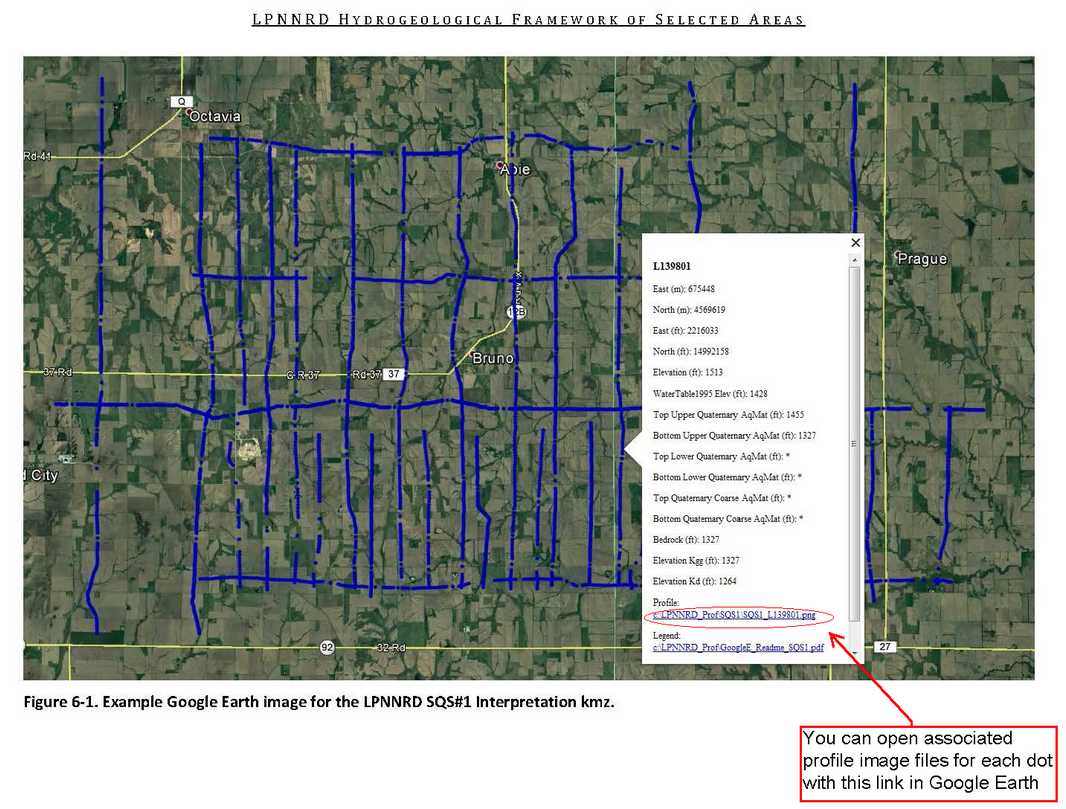
Google Earth Tips and Tricks: Grab the map with your cursor and hold down the "u" key on your keyboard to view the earth looking straight down instead of at an angle. Do the same and hit the "n" key to orient the map north as up. Google Earth Pro (link above) is free and you can hit the file menu, then hit open, and then select all data import formats from the dropdown and open an ESRI shapefile or many other GIS file types in Google Earth directly from a saved location on your computer.
Lower Platte South NRD 2016 AEM Survey
Links
Google Earth Datasets:
The interpreted results for the 2016 AEM flights have been provided in Google Earth format. You can download the free version of Google Earth Pro by clicking here.
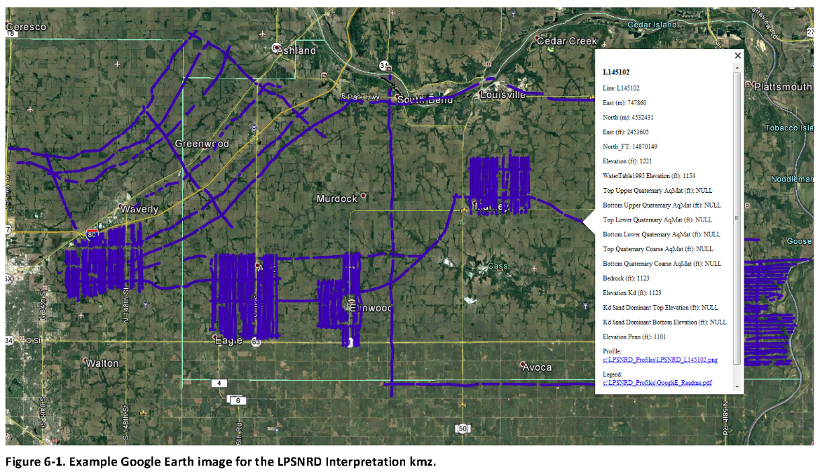
Click here for a link to download the LPSNRD Google Earth datasets (207 MB: one ".kmz" file and 164 images) from ENWRA's Dropbox.
You do not need to sign-up for a Dropbox account to download the files (button can be hard to spot, if you already have a Dropbox account please logout and choose download so you do not fill up space on your personal Dropbox). You must have Google Earth installed on your computer before downloading or opening the .kmz Google Earth dataset files.
Please follow the instructions in the GoogleE_README.pdf legend file on Dropbox here AND save the downloaded files with the same exact file structure as shown on the Dropbox. Google Earth will look here on your hard drive: C:\LPSNRD_Profiles\ for every profile image when you touch a link on a data dot in Google Earth - see example image below. The files on your C drive must all be unzipped in order to work from Google Earth. For example: you can create a folder called "LPSNRD_Profiles" directly on your C drive, unzip the files wherever your browser typically saves downloaded files, and then save the unzipped downloaded files to that "LPSNRD_Profiles" folder on your C.
Google Earth Tips and Tricks: Grab the map with your cursor and hold down the "u" key on your keyboard to view the earth looking straight down instead of at an angle. Do the same and hit the "n" key to orient the map north as up. Google Earth Pro (link above) is free and you can hit the file menu, then hit open, and then select all data import formats from the dropdown and open an ESRI shapefile or many other GIS file types in Google Earth directly from a saved location on your computer.
Papio-Missouri River NRD 2016 AEM Survey
Links
Google Earth Datasets:
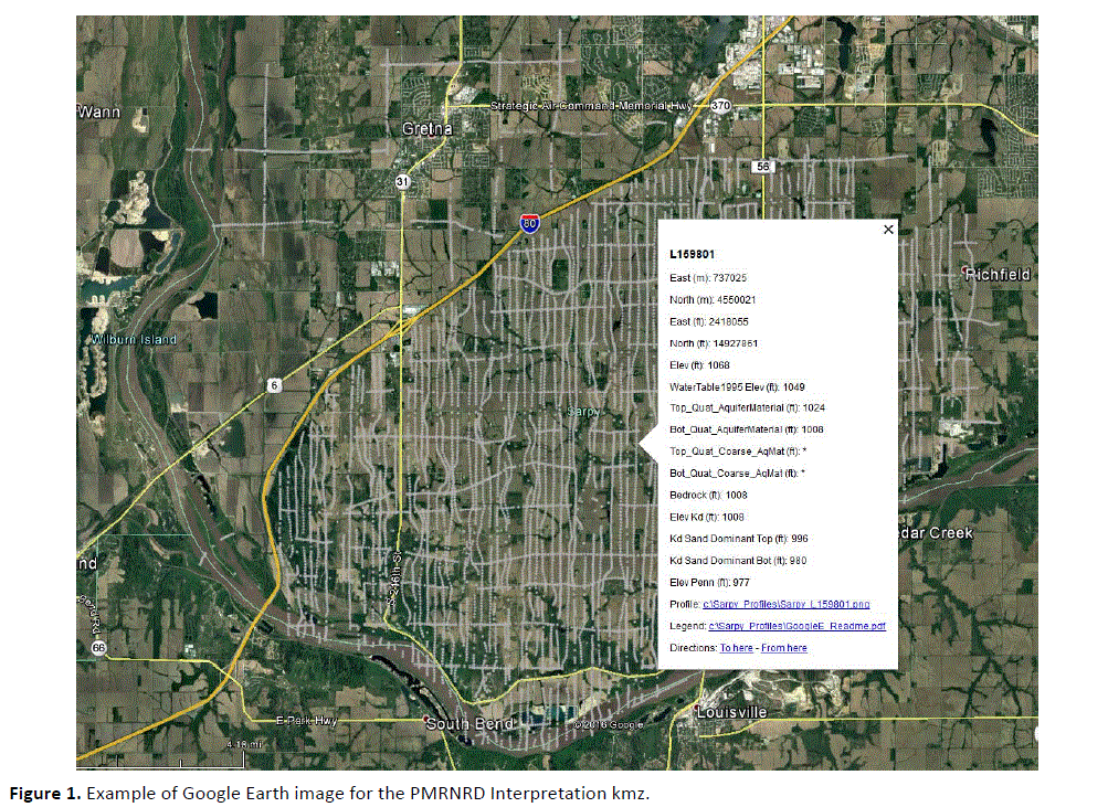
The interpreted results for the 2016 AEM flights have been provided in Google Earth format. You can download the free version of Google Earth Pro by clicking here. Click here for a link to download the Google Earth datasets (.kmz file and associated image files, 80.5 MB) from ENWRA's Dropbox. You do not need to sign-up for a Dropbox account to download the files. You must have Google Earth installed on your computer before downloading or opening the .kmz Google Earth dataset files. If you already have a Dropbox account, please logout and choose download so you do not fill up space on your personal Dropbox (location and method always getting updated by Dropbox, link can be hard to find).
Please follow the instructions in the "GoogleE_README.pdf" PDF file on Dropbox here AND save the downloaded files with the same exact file structure as shown on the Dropbox. Google Earth will look here on your hard drive: C:\Sarpy_Profiles\ for every profile image when you touch a link on a data dot - see example image below. The easiest way is to do this is to create a folder named "Sarpy_Profiles" directly on your C drive and then save all the downloaded Dropbox files to that folder.
Google Earth Tips and Tricks: Grab the map with your cursor and hold down the "u" key on your keyboard to view the earth looking straight down instead of at an angle. Do the same and hit the "n" key to orient the map north as up. Google Earth Pro (link above) is free and you can hit the file menu, then hit open, and then select all data import formats from the dropdown and open an ESRI shapefile or many other GIS file types in Google Earth directly from a saved location on your computer.
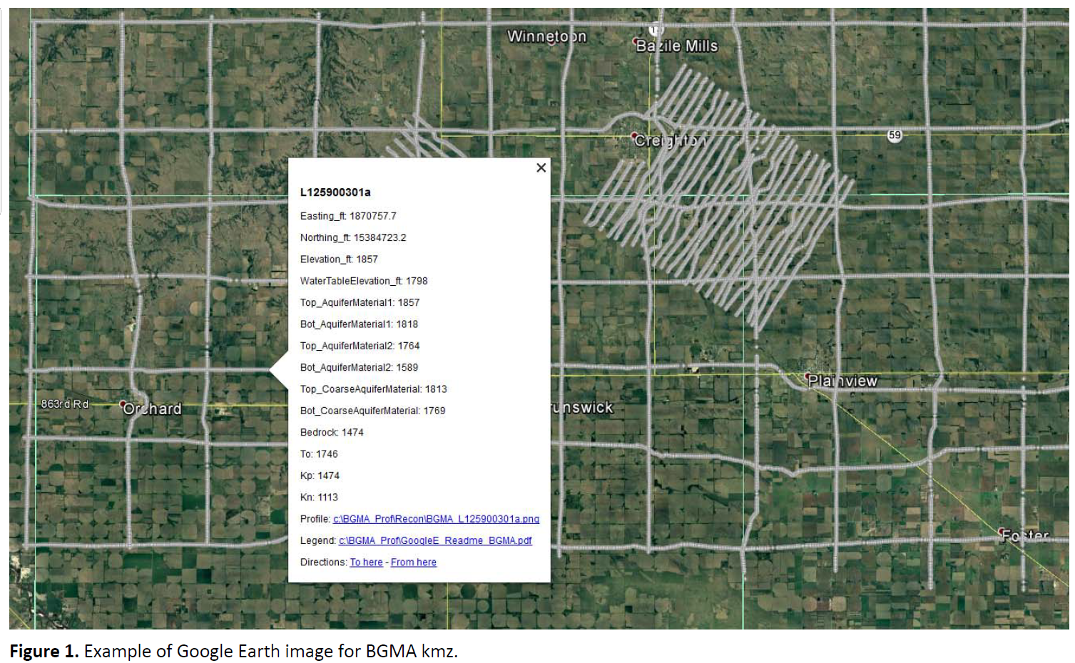
Bazile Groundwater Management Area 2016 AEM Survey
Links
Google Earth Datasets:
The interpreted results for the 2016 AEM flights have been provided in Google Earth format. You can download the free version of Google Earth Pro by clicking here. Click here for a link to download the Google Earth datasets (.kmz files) from ENWRA's Dropbox (you do not need to sign-up for a Dropbox account to download the files, button can be hard to spot). If you already have a Dropbox account, please logout and choose download so you don't fill up your personal Dropbox. You must have Google Earth installed on your computer before opening the .kmz Google Earth dataset files.
Please follow the instructions in the GoogleE_README_BGMA.pdf file on Dropbox here AND save the downloaded files with the same exact file structure as shown on the dropbox (including the main folder entitled BGMA_Prof). Google Earth will look here on your hard drive: C:\BGMA_Prof\ for every profile image when you touch a link on a data dot in Google Earth - see example image below). The files on your C drive must all be unzipped in order to work from Google Earth.
Google Earth Tips and Tricks: Grab the map with your cursor and hold down the "u" key on your keyboard to view the earth looking straight down instead of at an angle. Do the same and hit the "n" key to orient the map north as up. Google Earth Pro (link above) is free and you can hit the file menu, then hit open, and then select all data import formats from the dropdown and open an ESRI shapefile or many other GIS file types in Google Earth directly from a saved location on your computer.
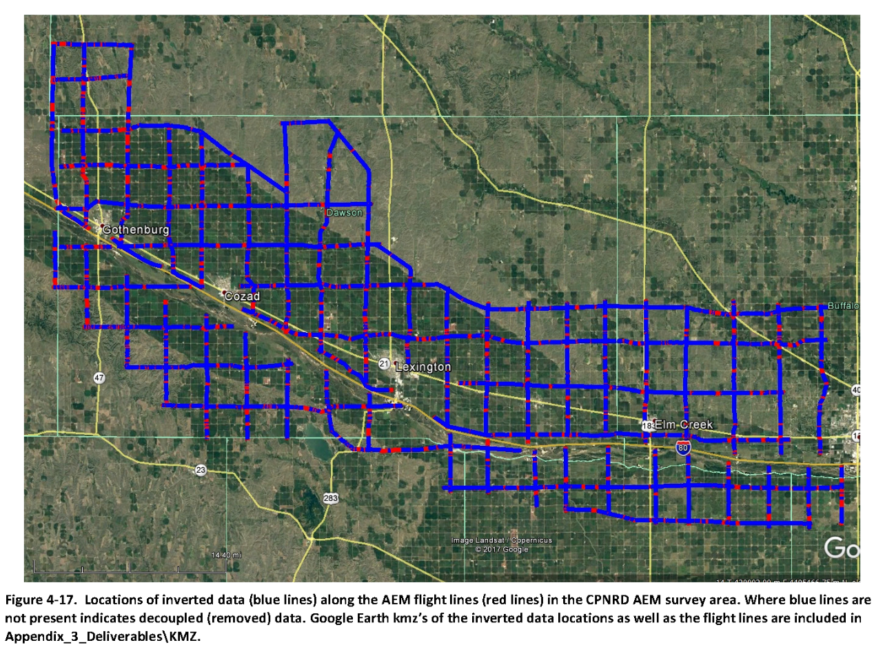
Twin Platte and Central Platte NRD 2016 AEM Surveys
Links
Google Earth Datasets:
The interpreted results for the 2016 AEM flights have been provided in Google Earth format. You can download the free version of Google Earth Pro by clicking here.
Click here for a link to download the CPNRD Google Earth datasets (53 MB: .kmz file with 90 images) from ENWRA's Dropbox.
Click here for a link to download the TPNRD Google Earth datasets (45 MB: .kmz file with 78 images) from ENWRA's Dropbox.
Click here for a link to download the PRRIP Google Earth datasets (10 MB: .kmz file with 17 images) from ENWRA's Dropbox.
Click here for a link to download the N-CORPE Google Earth datasets (15 MB: .kmz file with 30 images) from ENWRA's Dropbox.
You do not need to sign-up for a Dropbox account to download the files (button can be hard to spot). You must have Google Earth installed on your computer before downloading or opening the .kmz Google Earth dataset files. If you already have a Dropbox account, please logout and choose download so you do not fill up space on your personal Dropbox.
Please follow the instructions in the GoogleE_CP_README.pdf, GoogleE_TP_README.pdf, GoogleE_PR_README.pdf, and GoogleE_N_README.pdf legend files on Dropbox here, here, here, and here (respectively) AND save the downloaded files with the same exact file structure as shown on the Dropbox. Google Earth will look here on your hard drive: C:\CPNRD_Profiles\ (flights within CPNRD), C:\TPNRD_Profiles\ (flights within TPNRD), C:\PRRIP_Profiles\ (flights within PRRIP area), OR C:\NCORPE_Profiles\ (flights within N-CORPE area) for every profile image when you touch a link on a data dot in Google Earth - see example image below. The files on your C drive must all be unzipped in order to work from Google Earth. For example: you can create a folder called "CPNRD_Profiles" directly on your C drive, unzip the files wherever your browser typically saves downloaded files, and then save the unzipped downloaded files to that "CPNRD_Profiles" folder on your C.
Google Earth Tips and Tricks: Grab the map with your cursor and hold down the "u" key on your keyboard to view the earth looking straight down instead of at an angle. Do the same and hit the "n" key to orient the map north as up. Google Earth Pro (link above) is free and you can hit the file menu, then hit open, and then select all data import formats from the dropdown and open an ESRI shapefile or many other GIS file types in Google Earth directly from a saved location on your computer