Papio-Missouri River___Lewis & Clark___Lower Elkhorn___Lower Platte North___Lower Platte South
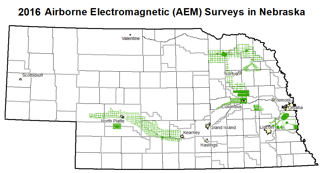
2016 Airborne Electromagnetic Survey (AEM) Flights
![]() The 2016 AEM survey data is now available at the Nebraska GeoCloud (NGC): "https://snr.unl.edu/csd/geology/nebraskageocloud.aspx"). The NGC is a web-based digital platform for geophysical, geological, and groundwater data and models. The purpose of the NGC is to archive Nebraska’s vast volume of data and make it accessible to both model builders and model users.
The 2016 AEM survey data is now available at the Nebraska GeoCloud (NGC): "https://snr.unl.edu/csd/geology/nebraskageocloud.aspx"). The NGC is a web-based digital platform for geophysical, geological, and groundwater data and models. The purpose of the NGC is to archive Nebraska’s vast volume of data and make it accessible to both model builders and model users.
Several Natural Resources Districts (NRDs) across the state conducted AEM flights in July and early August 2016 using Water Sustainability Fund (WSF) grant dollars awarded in April 2016 ("https://nrc.nebraska.gov/water-sustainability-fund-0").
Each NRD had a mix of the following types of surveys flown:
- block flights (tightly spaced flight lines for determining aquifer boundaries and/or potential groundwater volumes)
- transect/tie line flights (longer reconnaissance type flight lines)
- grid flights (hybrid of reconnaissance and detailed type suveys, aquifer boundary mapping)
Click ![]() here for a Shapefile Download (5.4 MB) or
here for a Shapefile Download (5.4 MB) or ![]() here for a kmz file Download (5.2 MB) of all the statewide flight lines including the 2016 AEM lines. The Lewis and Clark NRD has a separate interactive map of 2014-2018 flight lines within 5 miles of the District available:
here for a kmz file Download (5.2 MB) of all the statewide flight lines including the 2016 AEM lines. The Lewis and Clark NRD has a separate interactive map of 2014-2018 flight lines within 5 miles of the District available: ![]() Shapefile Download (1.5 MB)
Shapefile Download (1.5 MB) ![]() kmz file Download (0.3 MB).
kmz file Download (0.3 MB).
Papio-Missouri River___Lewis & Clark___Lower Elkhorn___Lower Platte North___Lower Platte South
Please refer to the AEM PARTNER PROJECTS TAB For The CENTRAL PLATTE, TWIN PLATTE and LOWER LOUP NRD 2016 Report Deliverables & THE BAZILE AREA 2016 AEM ReportPapio-Missouri River NRD 2016 AEM Results
Documents
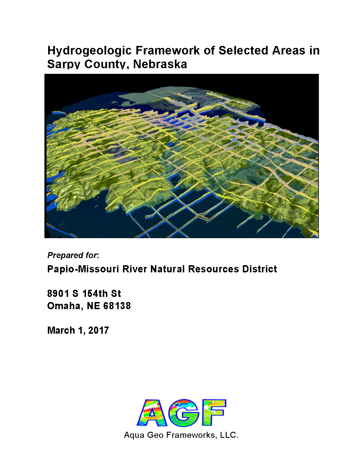
Airborne Hydrogeologic Framework of Selected Areas in
Sarpy County, Nebraska
 Report Text (PDF, 36.3 MB)
Appendix 1 (PDF, 29.6 MB)
Appendix 2 (PDF, 21.6 MB)
Datasets
Google Earth Datasets:
The interpreted results for the 2016 AEM flights have been provided in Google Earth format. You can download the free version of Google Earth Pro by clicking here. Click here for a link to download the Google Earth datasets (.kmz file and associated image files, 80.5 MB) from ENWRA's Dropbox. You can select "no thanks" to the sign-up for a Dropbox account and still download the files.
You must have Google Earth installed on your computer before downloading or opening the .kmz Google Earth dataset files.
If you already have a Dropbox account, please choose direct download to your computer so you do not fill up space on your personal Dropbox.
Please follow the instructions in the "GoogleE_README.pdf" PDF file on Dropbox here AND save the downloaded files with the same exact file structure as shown on the Dropbox. Google Earth will look here on your hard drive: C:\Sarpy_Profiles\ for every profile image when you touch a link on a data dot - see example image below. The easiest way is to do this is to create a folder named "Sarpy_Profiles" directly on your C drive and then save all the downloaded dropbox files to that folder.
 Google Earth Tips and Tricks:
Grab the map with your cursor and hold down the "u" key on your keyboard to view the earth looking straight down instead of at an angle. Do the same and hit the "n" key to orient the map north as up.
Google Earth Pro (link above) is free and you can hit the file menu, then hit open, and then select all data import formats from the dropdown and open an ESRI shapefile or many other GIS file types in Google Earth directly from a saved location on your computer.
Google Earth Tips and Tricks:
Grab the map with your cursor and hold down the "u" key on your keyboard to view the earth looking straight down instead of at an angle. Do the same and hit the "n" key to orient the map north as up.
Google Earth Pro (link above) is free and you can hit the file menu, then hit open, and then select all data import formats from the dropdown and open an ESRI shapefile or many other GIS file types in Google Earth directly from a saved location on your computer.
Lewis and Clark NRD 2016 AEM Results
Documents
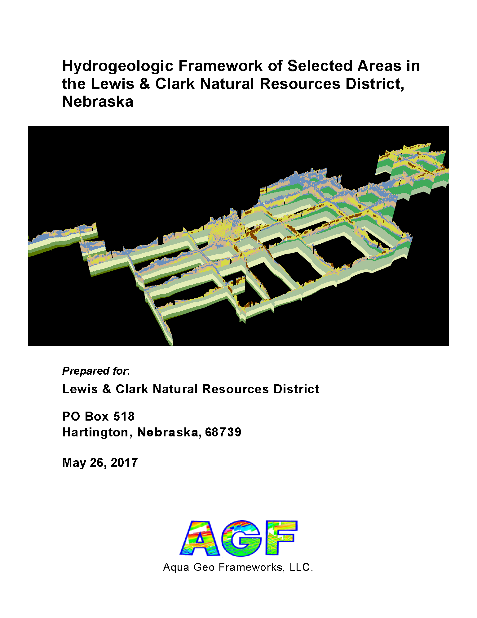
Hydrogeologic Framework of Selected Areas in the Lewis and Clark Natural Resources District, Nebraska
Report Text (PDF, 32 MB)
Appendix 1 LCNRD Coleridge Block AEM 2D Profiles (PDF, 15 MB)
Appendix 1 LCNRD Reconnaissance AEM 2D Profiles (PDF, 21 MB)
Appendix 2 LCNRD Coleridge Block AEM 3D Fence Diagrams (PDF, 3.9 MB)
Appendix 2 LCNRD Reconnaissance AEM 3D Fence Diagrams (PDF, 2.4 MB)
Datasets
Google Earth Datasets:
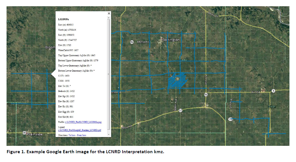
The interpreted results for the 2016 AEM flights have been provided in Google Earth format. You can download the free version of Google Earth Pro by clicking here. Click here for a link to download the Google Earth datasets (.kmz file and 58 associated image files, 31 MB) from ENWRA's Dropbox. You can select "no thanks" to the sign-up for a Dropbox account and still download the files (upper right, download button).
You must have Google Earth installed on your computer before downloading or opening the .kmz Google Earth dataset files.
If you already have a Dropbox account, please choose direct download to your computer so you do not fill up space on your personal Dropbox.
Please follow the instructions in the "GoogleE_README.pdf" PDF file on Dropbox here AND save the downloaded files with the same exact file structure as shown on the Dropbox. Google Earth will look here on your hard drive: C:\LCNRD_Prof\ for every profile image when you touch a link on a data dot - see example image below. An easy way is to do this is to create a folder named "LCNRD_Prof" directly on your C drive, download and unzip the Dropbox files wherever your browser typically puts downloaded files, and then save all the downloaded, unzipped files to that LCNRD_Prof folder.
 Google Earth Tips and Tricks:
Grab the map with your cursor and hold down the "u" key on your keyboard to view the earth looking straight down instead of at an angle. Do the same and hit the "n" key to orient the map north as up.
Google Earth Pro (link above) is free and you can hit the file menu, then hit open, and then select all data import formats from the dropdown and open an ESRI shapefile or many other GIS file types in Google Earth directly from a saved location on your computer.
Google Earth Tips and Tricks:
Grab the map with your cursor and hold down the "u" key on your keyboard to view the earth looking straight down instead of at an angle. Do the same and hit the "n" key to orient the map north as up.
Google Earth Pro (link above) is free and you can hit the file menu, then hit open, and then select all data import formats from the dropdown and open an ESRI shapefile or many other GIS file types in Google Earth directly from a saved location on your computer.
Lower Elkhorn NRD 2016 AEM Results Documents
Hydrogeologic Framework of Selected Areas in the Lower Elkhorn Natural Resources District, Nebraska

Report Text (PDF, 32 MB)
Appendix 1 LENRD 2D Profiles Resistivity Aquifer Interpretation (PDF, 55 MB)
Appendix 2 LENRD 3D Fence Diagrams (PDF, 3.5 MB)
Datasets
Google Earth Datasets:
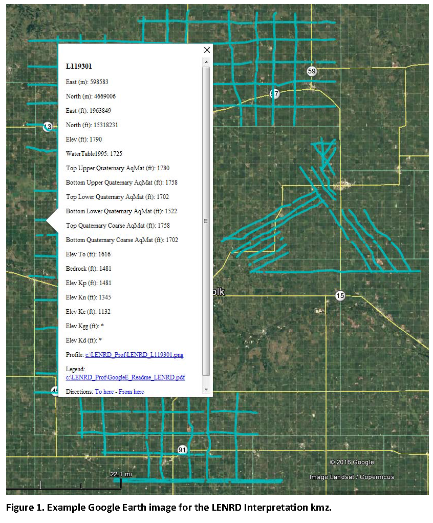
The interpreted results for the 2016 AEM flights have been provided in Google Earth format. You can download the free version of Google Earth Pro by clicking here. Click here for a link to download the Google Earth datasets (.kmz file and 128 associated image files, 74 MB) from ENWRA's Dropbox. You can select "no thanks" to the sign-up for a Dropbox account and still download the files (upper right, download button).
You must have Google Earth installed on your computer before downloading or opening the .kmz Google Earth dataset files.
If you already have a Dropbox account, please choose direct download to your computer so you do not fill up space on your personal Dropbox.
Please follow the instructions in the "GoogleE_README_LENRD.pdf" PDF file on Dropbox here AND save the downloaded files with the same exact file structure as shown on the Dropbox. Google Earth will look here on your hard drive: C:\LENRD_Prof\ for every profile image when you touch a link on a data dot - see example image below. An easy way is to do this is to create a folder named "LENRD_Prof" directly on your C drive, download and unzip the Dropbox files wherever your browser typically puts downloaded files, and then save all the downloaded, unzipped files to that LENRD_Prof folder.
 Google Earth Tips and Tricks:
Grab the map with your cursor and hold down the "u" key on your keyboard to view the earth looking straight down instead of at an angle. Do the same and hit the "n" key to orient the map north as up.
Google Earth Pro (link above) is free and you can hit the file menu, then hit open, and then select all data import formats from the dropdown and open an ESRI shapefile or many other GIS file types in Google Earth directly from a saved location on your computer.
Google Earth Tips and Tricks:
Grab the map with your cursor and hold down the "u" key on your keyboard to view the earth looking straight down instead of at an angle. Do the same and hit the "n" key to orient the map north as up.
Google Earth Pro (link above) is free and you can hit the file menu, then hit open, and then select all data import formats from the dropdown and open an ESRI shapefile or many other GIS file types in Google Earth directly from a saved location on your computer.
Lower Platte North NRD 2016 AEM Results Documents
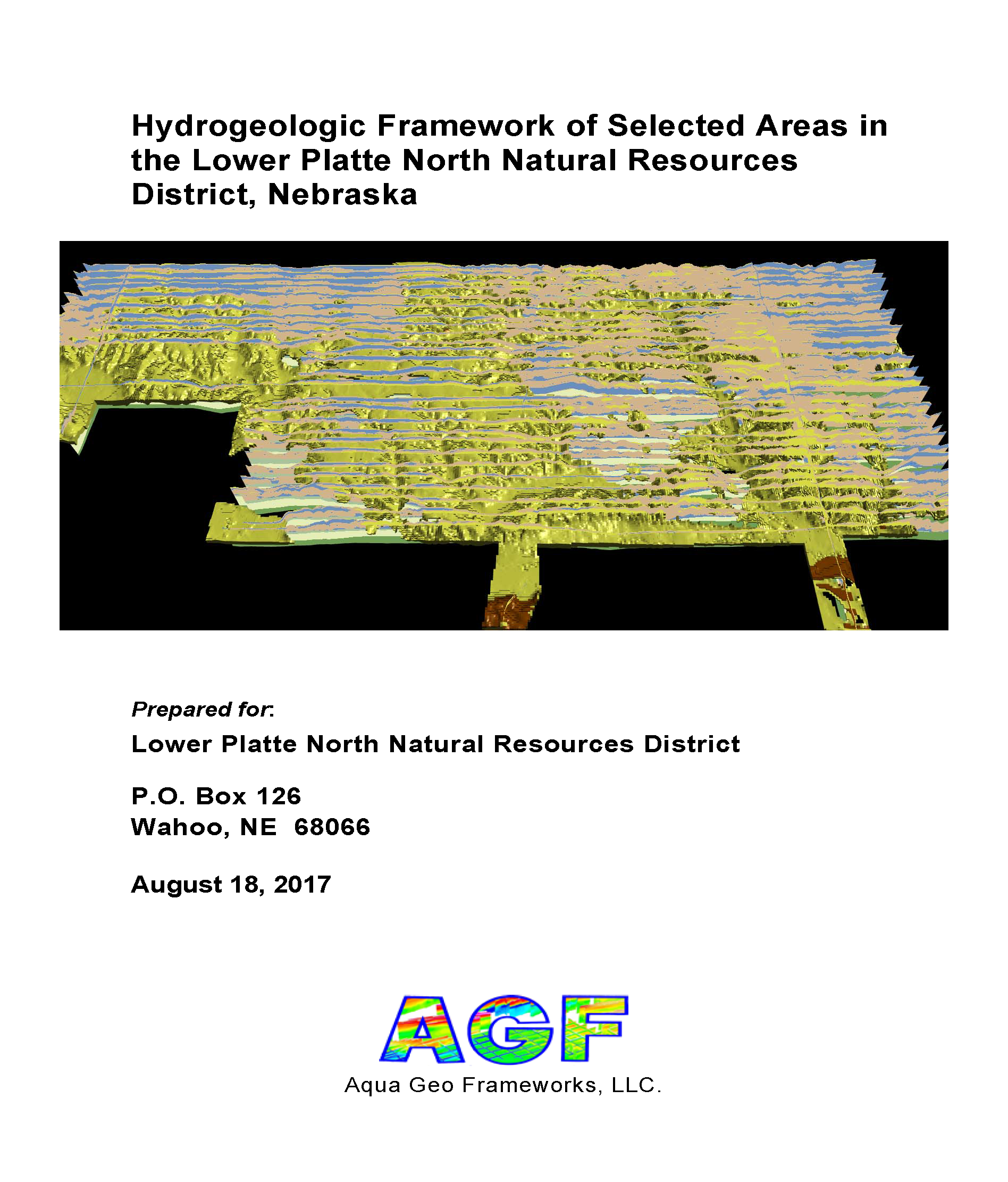
Hydrogeologic Framework of Selected Areas in the Lower Platte North Natural Resources District, Nebraska
Report Text (PDF, 37 MB)
Appendix 1 SQS1 2D Profiles Aquifer Interpretation (PDF, 24 MB)
Appendix 1 SQS2 2D Profiles Aquifer Interpretation (PDF, 31 MB)
Appendix 2 SQS1 3D Fence Diagrams (PDF, 3.8 MB)
Appendix 2 SQS2 3D Fence Diagrams (PDF, 4.0 MB)
Appendix 2 SQS1 3D Voxel Surfaces (PDF, 2.6 MB)
Appendix 2 SQS2 3D Voxel Surfaces (PDF, 3.3 MB)
Datasets
Google Earth Datasets:
The interpreted results for the 2016 AEM flights have been provided in Google Earth format. You can download the free version of Google Earth Pro by clicking here. Click here for a link to download the Google Earth datasets (two ".kmz" files and 96 associated image files, 30 for SQS1 and 66 for SQS2, totalling 132 MB) from ENWRA's Dropbox. You can select "no thanks" to the sign-up for a Dropbox account and still download the files (upper right, download button).
You must have Google Earth installed on your computer before downloading or opening the ".kmz" Google Earth dataset files.
If you already have a Dropbox account, please choose direct download to your computer so you do not fill up space on your personal Dropbox.
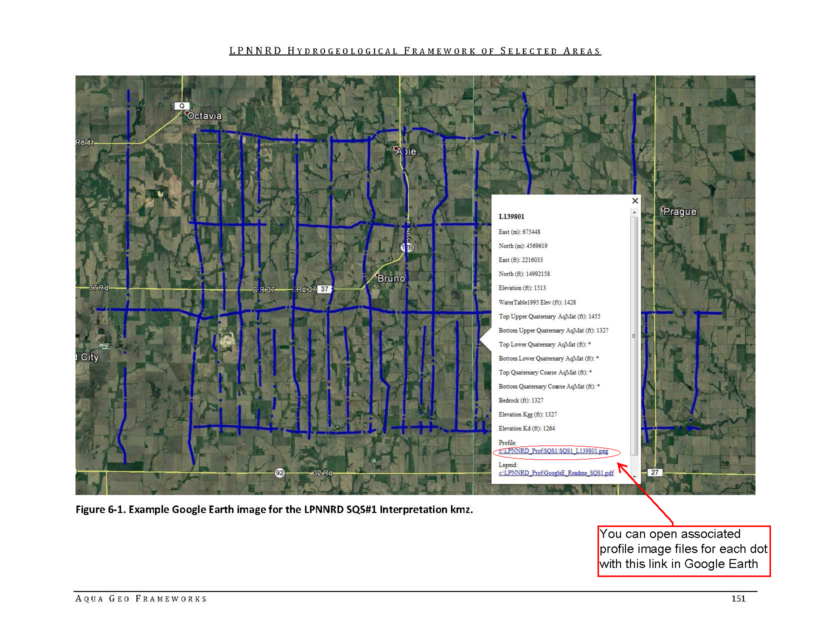
Please follow the instructions in the "GoogleE_README_SQS1.pdf" PDF file on Dropbox here and "GoogleE_README_SQS2.pdf" PDF file on Dropbox here. Save the downloaded files with the same exact file structure as shown on the Dropbox. Google Earth will look here on your hard drive: C:\LPNNRD_Prof\ for every profile image when you touch a link on a data dot - see example image below. An easy way is to do this is to create a folder named "LPNNRD_Prof" directly on your C drive, download and unzip the Dropbox files wherever your browser typically puts downloaded files, and then save all the downloaded, unzipped files to that LPNNRD_Prof folder.
 Google Earth Tips and Tricks:
Grab the map with your cursor and hold down the "u" key on your keyboard to view the earth looking straight down instead of at an angle. Do the same and hit the "n" key to orient the map north as up.
Google Earth Pro (link above) is free and you can hit the file menu, then hit open, and then select all data import formats from the dropdown and open an ESRI shapefile or many other GIS file types in Google Earth directly from a saved location on your computer.
Google Earth Tips and Tricks:
Grab the map with your cursor and hold down the "u" key on your keyboard to view the earth looking straight down instead of at an angle. Do the same and hit the "n" key to orient the map north as up.
Google Earth Pro (link above) is free and you can hit the file menu, then hit open, and then select all data import formats from the dropdown and open an ESRI shapefile or many other GIS file types in Google Earth directly from a saved location on your computer.
Lower Platte South NRD 2016 AEM Results Documents
Hydrogeologic Framework of Selected Areas in
the Lower Platte South Natural Resources District,
Nebraska
Report Text (PDF from Dropbox - you can select "no thanks" to the sign-up for a Dropbox account and still download the files, 36 MB)
Appendix 1: Eagle 2D Profiles
with Resistivity and Aquifer Interpretation (PDFs from Dropbox, 22.7 MB)
Appendix 1: Elmwood 2D Profiles
with Resistivity and Aquifer Interpretation (PDFs from Dropbox, 15.6 MB)
Appendix 1: Reconnaissance 2D Profiles
with Resistivity and Aquifer Interpretation (PDFs from Dropbox, 15.3 MB)
Appendix 1: Union 2D Profiles
with Resistivity and Aquifer Interpretation (PDFs from Dropbox, 27.1 MB)
Appendix 1: Waverly 2D Profiles with Resistivity and Aquifer
Interpretation (PDFs from Dropbox, 25.9 MB)
Appendix 1: Weeping Water 2D Profiles with Resistivity and Aquifer
Interpretation (PDFs from Dropbox, 17.8 MB)
Appendix 2: Eagle 2D Surfaces (PDFs from Dropbox, 6.5 MB)
Appendix 2: Eagle 3D Voxel Fence Diagrams (PDFs from Dropbox, 1.1 MB)
Appendix 2: Elmwood 2D Surfaces (PDFs from Dropbox, 5.2 MB)
Appendix 2: Elmwood 3D Voxel Fence Diagrams (PDFs from Dropbox, 1.1 MB)
Appendix 2: Reconnaissance 3D Fence Diagrams (PDFs from Dropbox, 1.6 MB)
Appendix 2: Salt Creek 2D Surfaces (PDFs from Dropbox, 6.3 MB)
Appendix 2: Salt Creek 3D Voxel Fence Diagrams (PDFs from Dropbox, 2.7 MB)
Appendix 2: Union 2D Surfaces (PDFs from Dropbox, 5.2 MB)
Appendix 2: Union 3D Voxel Fence Diagrams (PDFs from Dropbox, 1.4 MB)
Appendix 2: Waverly 2D Surfaces (PDFs from Dropbox, 8.2 MB)
Appendix 2: Waverly 3D Voxel Fence Diagrams (PDFs from Dropbox, 1.4 MB)
Appendix 2: Weeping Water 2D Surfaces (PDFs from Dropbox, 7.3 MB)
Appendix 2: Weeping Water 3D Voxel Fence Diagrams (PDFs from Dropbox, 1.1 MB)
Datasets
Google Earth Datasets:
The interpreted results for the 2016 AEM flights have been provided in Google Earth format. You can download the free version of Google Earth Pro by clicking here.
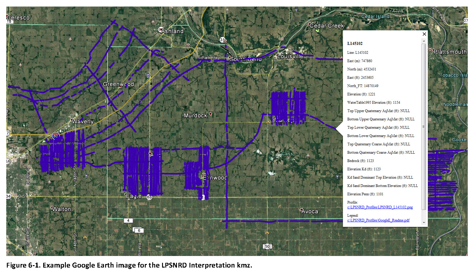
Click here for a link to download the LPSNRD Google Earth datasets (207 MB: one ".kmz" file and 164 images) from ENWRA's Dropbox.
You can select "no thanks" to the sign-up for a Dropbox account and still download the files.
You must have Google Earth installed on your computer before downloading or opening the .kmz Google Earth dataset files.
If you already have a dropbox account, please choose direct download to your computer so you do not fill up space on your personal Dropbox.
Please follow the instructions in the GoogleE_README.pdf legend file on Dropbox here AND save the downloaded files with the same exact file structure as shown on the Dropbox. Google Earth will look here on your hard drive: C:\LPSNRD_Profiles\ for every profile image when you touch a link on a data dot in Google Earth - see example image below. The files on your C drive must all be unzipped in order to work from Google Earth. For example: you can create a folder called "LPSNRD_Profiles" directly on your C drive, unzip the files wherever your browser typically saves downloaded files, and then save the unzipped downloaded files to that "LPSNRD_Profiles" folder on your C.
 Google Earth Tips and Tricks:
Grab the map with your cursor and hold down the "u" key on your keyboard to view the earth looking straight down instead of at an angle. Do the same and hit the "n" key to orient the map north as up.
Google Earth Pro (link above) is free and you can hit the file menu, then hit open, and then select all data import formats from the dropdown and open an ESRI shapefile or many other GIS file types in Google Earth directly from a saved location on your computer.
Google Earth Tips and Tricks:
Grab the map with your cursor and hold down the "u" key on your keyboard to view the earth looking straight down instead of at an angle. Do the same and hit the "n" key to orient the map north as up.
Google Earth Pro (link above) is free and you can hit the file menu, then hit open, and then select all data import formats from the dropdown and open an ESRI shapefile or many other GIS file types in Google Earth directly from a saved location on your computer.
Please Refer To The AEM PARTNER PROJECTS TAB For The CENTRAL PLATTE, TWIN PLATTE and LOWER LOUP NRD 2016 Report Deliverables & THE BAZILE AREA 2016 AEM Report
Documents
Airborne Hydrogeologic Framework of Selected Areas in Sarpy County, Nebraska
![]() Report Text (PDF, 36.3 MB)
Report Text (PDF, 36.3 MB)
![]() Appendix 1 (PDF, 29.6 MB)
Appendix 1 (PDF, 29.6 MB)
![]() Appendix 2 (PDF, 21.6 MB)
Appendix 2 (PDF, 21.6 MB)
Datasets
Google Earth Datasets:
The interpreted results for the 2016 AEM flights have been provided in Google Earth format. You can download the free version of Google Earth Pro by clicking here. Click here for a link to download the Google Earth datasets (.kmz file and associated image files, 80.5 MB) from ENWRA's Dropbox. You can select "no thanks" to the sign-up for a Dropbox account and still download the files. You must have Google Earth installed on your computer before downloading or opening the .kmz Google Earth dataset files.
If you already have a Dropbox account, please choose direct download to your computer so you do not fill up space on your personal Dropbox.
Please follow the instructions in the "GoogleE_README.pdf" PDF file on Dropbox here AND save the downloaded files with the same exact file structure as shown on the Dropbox. Google Earth will look here on your hard drive: C:\Sarpy_Profiles\ for every profile image when you touch a link on a data dot - see example image below. The easiest way is to do this is to create a folder named "Sarpy_Profiles" directly on your C drive and then save all the downloaded dropbox files to that folder.
 Google Earth Tips and Tricks:
Grab the map with your cursor and hold down the "u" key on your keyboard to view the earth looking straight down instead of at an angle. Do the same and hit the "n" key to orient the map north as up.
Google Earth Pro (link above) is free and you can hit the file menu, then hit open, and then select all data import formats from the dropdown and open an ESRI shapefile or many other GIS file types in Google Earth directly from a saved location on your computer.
Google Earth Tips and Tricks:
Grab the map with your cursor and hold down the "u" key on your keyboard to view the earth looking straight down instead of at an angle. Do the same and hit the "n" key to orient the map north as up.
Google Earth Pro (link above) is free and you can hit the file menu, then hit open, and then select all data import formats from the dropdown and open an ESRI shapefile or many other GIS file types in Google Earth directly from a saved location on your computer.
Lewis and Clark NRD 2016 AEM Results
Documents
Hydrogeologic Framework of Selected Areas in the Lewis and Clark Natural Resources District, Nebraska
Report Text (PDF, 32 MB)
Appendix 1 LCNRD Coleridge Block AEM 2D Profiles (PDF, 15 MB)
Appendix 1 LCNRD Reconnaissance AEM 2D Profiles (PDF, 21 MB)
Appendix 2 LCNRD Coleridge Block AEM 3D Fence Diagrams (PDF, 3.9 MB)
Appendix 2 LCNRD Reconnaissance AEM 3D Fence Diagrams (PDF, 2.4 MB)
Datasets
Google Earth Datasets:
The interpreted results for the 2016 AEM flights have been provided in Google Earth format. You can download the free version of Google Earth Pro by clicking here. Click here for a link to download the Google Earth datasets (.kmz file and 58 associated image files, 31 MB) from ENWRA's Dropbox. You can select "no thanks" to the sign-up for a Dropbox account and still download the files (upper right, download button).
You must have Google Earth installed on your computer before downloading or opening the .kmz Google Earth dataset files.
If you already have a Dropbox account, please choose direct download to your computer so you do not fill up space on your personal Dropbox.
Please follow the instructions in the "GoogleE_README.pdf" PDF file on Dropbox here AND save the downloaded files with the same exact file structure as shown on the Dropbox. Google Earth will look here on your hard drive: C:\LCNRD_Prof\ for every profile image when you touch a link on a data dot - see example image below. An easy way is to do this is to create a folder named "LCNRD_Prof" directly on your C drive, download and unzip the Dropbox files wherever your browser typically puts downloaded files, and then save all the downloaded, unzipped files to that LCNRD_Prof folder.
Google Earth Tips and Tricks:
Grab the map with your cursor and hold down the "u" key on your keyboard to view the earth looking straight down instead of at an angle. Do the same and hit the "n" key to orient the map north as up.
Google Earth Pro (link above) is free and you can hit the file menu, then hit open, and then select all data import formats from the dropdown and open an ESRI shapefile or many other GIS file types in Google Earth directly from a saved location on your computer.
Lower Elkhorn NRD 2016 AEM Results Documents
Hydrogeologic Framework of Selected Areas in the Lower Elkhorn Natural Resources District, Nebraska
Report Text (PDF, 32 MB)
Appendix 1 LENRD 2D Profiles Resistivity Aquifer Interpretation (PDF, 55 MB)
Appendix 2 LENRD 3D Fence Diagrams (PDF, 3.5 MB)
Datasets
Google Earth Datasets:
The interpreted results for the 2016 AEM flights have been provided in Google Earth format. You can download the free version of Google Earth Pro by clicking here. Click here for a link to download the Google Earth datasets (.kmz file and 128 associated image files, 74 MB) from ENWRA's Dropbox. You can select "no thanks" to the sign-up for a Dropbox account and still download the files (upper right, download button).
You must have Google Earth installed on your computer before downloading or opening the .kmz Google Earth dataset files.
If you already have a Dropbox account, please choose direct download to your computer so you do not fill up space on your personal Dropbox.
Please follow the instructions in the "GoogleE_README_LENRD.pdf" PDF file on Dropbox here AND save the downloaded files with the same exact file structure as shown on the Dropbox. Google Earth will look here on your hard drive: C:\LENRD_Prof\ for every profile image when you touch a link on a data dot - see example image below. An easy way is to do this is to create a folder named "LENRD_Prof" directly on your C drive, download and unzip the Dropbox files wherever your browser typically puts downloaded files, and then save all the downloaded, unzipped files to that LENRD_Prof folder.
Google Earth Tips and Tricks:
Grab the map with your cursor and hold down the "u" key on your keyboard to view the earth looking straight down instead of at an angle. Do the same and hit the "n" key to orient the map north as up.
Google Earth Pro (link above) is free and you can hit the file menu, then hit open, and then select all data import formats from the dropdown and open an ESRI shapefile or many other GIS file types in Google Earth directly from a saved location on your computer.
Lower Platte North NRD 2016 AEM Results Documents
Hydrogeologic Framework of Selected Areas in the Lower Platte North Natural Resources District, Nebraska
Report Text (PDF, 37 MB)
Appendix 1 SQS1 2D Profiles Aquifer Interpretation (PDF, 24 MB)
Appendix 1 SQS2 2D Profiles Aquifer Interpretation (PDF, 31 MB)
Appendix 2 SQS1 3D Fence Diagrams (PDF, 3.8 MB)
Appendix 2 SQS2 3D Fence Diagrams (PDF, 4.0 MB)
Appendix 2 SQS1 3D Voxel Surfaces (PDF, 2.6 MB)
Appendix 2 SQS2 3D Voxel Surfaces (PDF, 3.3 MB)
Datasets
Google Earth Datasets:
The interpreted results for the 2016 AEM flights have been provided in Google Earth format. You can download the free version of Google Earth Pro by clicking here. Click here for a link to download the Google Earth datasets (two ".kmz" files and 96 associated image files, 30 for SQS1 and 66 for SQS2, totalling 132 MB) from ENWRA's Dropbox. You can select "no thanks" to the sign-up for a Dropbox account and still download the files (upper right, download button).
You must have Google Earth installed on your computer before downloading or opening the ".kmz" Google Earth dataset files.
If you already have a Dropbox account, please choose direct download to your computer so you do not fill up space on your personal Dropbox.
Please follow the instructions in the "GoogleE_README_SQS1.pdf" PDF file on Dropbox here and "GoogleE_README_SQS2.pdf" PDF file on Dropbox here. Save the downloaded files with the same exact file structure as shown on the Dropbox. Google Earth will look here on your hard drive: C:\LPNNRD_Prof\ for every profile image when you touch a link on a data dot - see example image below. An easy way is to do this is to create a folder named "LPNNRD_Prof" directly on your C drive, download and unzip the Dropbox files wherever your browser typically puts downloaded files, and then save all the downloaded, unzipped files to that LPNNRD_Prof folder.
Google Earth Tips and Tricks:
Grab the map with your cursor and hold down the "u" key on your keyboard to view the earth looking straight down instead of at an angle. Do the same and hit the "n" key to orient the map north as up.
Google Earth Pro (link above) is free and you can hit the file menu, then hit open, and then select all data import formats from the dropdown and open an ESRI shapefile or many other GIS file types in Google Earth directly from a saved location on your computer.
Lower Platte South NRD 2016 AEM Results Documents
Hydrogeologic Framework of Selected Areas in
the Lower Platte South Natural Resources District,
Nebraska
Report Text (PDF from Dropbox - you can select "no thanks" to the sign-up for a Dropbox account and still download the files, 36 MB)
Appendix 1: Eagle 2D Profiles
with Resistivity and Aquifer Interpretation (PDFs from Dropbox, 22.7 MB)
Appendix 1: Elmwood 2D Profiles
with Resistivity and Aquifer Interpretation (PDFs from Dropbox, 15.6 MB)
Appendix 1: Reconnaissance 2D Profiles
with Resistivity and Aquifer Interpretation (PDFs from Dropbox, 15.3 MB)
Appendix 1: Union 2D Profiles
with Resistivity and Aquifer Interpretation (PDFs from Dropbox, 27.1 MB)
Appendix 1: Waverly 2D Profiles with Resistivity and Aquifer
Interpretation (PDFs from Dropbox, 25.9 MB)
Appendix 1: Weeping Water 2D Profiles with Resistivity and Aquifer
Interpretation (PDFs from Dropbox, 17.8 MB)
Appendix 2: Eagle 2D Surfaces (PDFs from Dropbox, 6.5 MB)
Appendix 2: Eagle 3D Voxel Fence Diagrams (PDFs from Dropbox, 1.1 MB)
Appendix 2: Elmwood 2D Surfaces (PDFs from Dropbox, 5.2 MB)
Appendix 2: Elmwood 3D Voxel Fence Diagrams (PDFs from Dropbox, 1.1 MB)
Appendix 2: Reconnaissance 3D Fence Diagrams (PDFs from Dropbox, 1.6 MB)
Appendix 2: Salt Creek 2D Surfaces (PDFs from Dropbox, 6.3 MB)
Appendix 2: Salt Creek 3D Voxel Fence Diagrams (PDFs from Dropbox, 2.7 MB)
Appendix 2: Union 2D Surfaces (PDFs from Dropbox, 5.2 MB)
Appendix 2: Union 3D Voxel Fence Diagrams (PDFs from Dropbox, 1.4 MB)
Appendix 2: Waverly 2D Surfaces (PDFs from Dropbox, 8.2 MB)
Appendix 2: Waverly 3D Voxel Fence Diagrams (PDFs from Dropbox, 1.4 MB)
Appendix 2: Weeping Water 2D Surfaces (PDFs from Dropbox, 7.3 MB)
Appendix 2: Weeping Water 3D Voxel Fence Diagrams (PDFs from Dropbox, 1.1 MB)
Datasets
Google Earth Datasets:
The interpreted results for the 2016 AEM flights have been provided in Google Earth format. You can download the free version of Google Earth Pro by clicking here.
Click here for a link to download the LPSNRD Google Earth datasets (207 MB: one ".kmz" file and 164 images) from ENWRA's Dropbox.
You can select "no thanks" to the sign-up for a Dropbox account and still download the files.
You must have Google Earth installed on your computer before downloading or opening the .kmz Google Earth dataset files.
If you already have a dropbox account, please choose direct download to your computer so you do not fill up space on your personal Dropbox.
Please follow the instructions in the GoogleE_README.pdf legend file on Dropbox here AND save the downloaded files with the same exact file structure as shown on the Dropbox. Google Earth will look here on your hard drive: C:\LPSNRD_Profiles\ for every profile image when you touch a link on a data dot in Google Earth - see example image below. The files on your C drive must all be unzipped in order to work from Google Earth. For example: you can create a folder called "LPSNRD_Profiles" directly on your C drive, unzip the files wherever your browser typically saves downloaded files, and then save the unzipped downloaded files to that "LPSNRD_Profiles" folder on your C.
Google Earth Tips and Tricks:
Grab the map with your cursor and hold down the "u" key on your keyboard to view the earth looking straight down instead of at an angle. Do the same and hit the "n" key to orient the map north as up.
Google Earth Pro (link above) is free and you can hit the file menu, then hit open, and then select all data import formats from the dropdown and open an ESRI shapefile or many other GIS file types in Google Earth directly from a saved location on your computer.
Please Refer To The AEM PARTNER PROJECTS TAB For The CENTRAL PLATTE, TWIN PLATTE and LOWER LOUP NRD 2016 Report Deliverables & THE BAZILE AREA 2016 AEM Report
Documents
Hydrogeologic Framework of Selected Areas in the Lewis and Clark Natural Resources District, Nebraska
![]() Report Text (PDF, 32 MB)
Report Text (PDF, 32 MB)
![]() Appendix 1 LCNRD Coleridge Block AEM 2D Profiles (PDF, 15 MB)
Appendix 1 LCNRD Coleridge Block AEM 2D Profiles (PDF, 15 MB)
![]() Appendix 1 LCNRD Reconnaissance AEM 2D Profiles (PDF, 21 MB)
Appendix 1 LCNRD Reconnaissance AEM 2D Profiles (PDF, 21 MB)
![]() Appendix 2 LCNRD Coleridge Block AEM 3D Fence Diagrams (PDF, 3.9 MB)
Appendix 2 LCNRD Coleridge Block AEM 3D Fence Diagrams (PDF, 3.9 MB)
![]() Appendix 2 LCNRD Reconnaissance AEM 3D Fence Diagrams (PDF, 2.4 MB)
Appendix 2 LCNRD Reconnaissance AEM 3D Fence Diagrams (PDF, 2.4 MB)
Datasets
Google Earth Datasets:
The interpreted results for the 2016 AEM flights have been provided in Google Earth format. You can download the free version of Google Earth Pro by clicking here. Click here for a link to download the Google Earth datasets (.kmz file and 58 associated image files, 31 MB) from ENWRA's Dropbox. You can select "no thanks" to the sign-up for a Dropbox account and still download the files (upper right, download button). You must have Google Earth installed on your computer before downloading or opening the .kmz Google Earth dataset files.
If you already have a Dropbox account, please choose direct download to your computer so you do not fill up space on your personal Dropbox.
Please follow the instructions in the "GoogleE_README.pdf" PDF file on Dropbox here AND save the downloaded files with the same exact file structure as shown on the Dropbox. Google Earth will look here on your hard drive: C:\LCNRD_Prof\ for every profile image when you touch a link on a data dot - see example image below. An easy way is to do this is to create a folder named "LCNRD_Prof" directly on your C drive, download and unzip the Dropbox files wherever your browser typically puts downloaded files, and then save all the downloaded, unzipped files to that LCNRD_Prof folder.
Google Earth Tips and Tricks:
Grab the map with your cursor and hold down the "u" key on your keyboard to view the earth looking straight down instead of at an angle. Do the same and hit the "n" key to orient the map north as up.
Google Earth Pro (link above) is free and you can hit the file menu, then hit open, and then select all data import formats from the dropdown and open an ESRI shapefile or many other GIS file types in Google Earth directly from a saved location on your computer.
Documents
Hydrogeologic Framework of Selected Areas in the Lower Elkhorn Natural Resources District, Nebraska
![]() Report Text (PDF, 32 MB)
Report Text (PDF, 32 MB)
![]() Appendix 1 LENRD 2D Profiles Resistivity Aquifer Interpretation (PDF, 55 MB)
Appendix 1 LENRD 2D Profiles Resistivity Aquifer Interpretation (PDF, 55 MB)
![]() Appendix 2 LENRD 3D Fence Diagrams (PDF, 3.5 MB)
Appendix 2 LENRD 3D Fence Diagrams (PDF, 3.5 MB)
Datasets
Google Earth Datasets:
The interpreted results for the 2016 AEM flights have been provided in Google Earth format. You can download the free version of Google Earth Pro by clicking here. Click here for a link to download the Google Earth datasets (.kmz file and 128 associated image files, 74 MB) from ENWRA's Dropbox. You can select "no thanks" to the sign-up for a Dropbox account and still download the files (upper right, download button). You must have Google Earth installed on your computer before downloading or opening the .kmz Google Earth dataset files.
If you already have a Dropbox account, please choose direct download to your computer so you do not fill up space on your personal Dropbox.
Please follow the instructions in the "GoogleE_README_LENRD.pdf" PDF file on Dropbox here AND save the downloaded files with the same exact file structure as shown on the Dropbox. Google Earth will look here on your hard drive: C:\LENRD_Prof\ for every profile image when you touch a link on a data dot - see example image below. An easy way is to do this is to create a folder named "LENRD_Prof" directly on your C drive, download and unzip the Dropbox files wherever your browser typically puts downloaded files, and then save all the downloaded, unzipped files to that LENRD_Prof folder.
Google Earth Tips and Tricks:
Grab the map with your cursor and hold down the "u" key on your keyboard to view the earth looking straight down instead of at an angle. Do the same and hit the "n" key to orient the map north as up.
Google Earth Pro (link above) is free and you can hit the file menu, then hit open, and then select all data import formats from the dropdown and open an ESRI shapefile or many other GIS file types in Google Earth directly from a saved location on your computer.
Documents
Hydrogeologic Framework of Selected Areas in the Lower Platte North Natural Resources District, Nebraska
![]() Report Text (PDF, 37 MB)
Report Text (PDF, 37 MB)
![]() Appendix 1 SQS1 2D Profiles Aquifer Interpretation (PDF, 24 MB)
Appendix 1 SQS1 2D Profiles Aquifer Interpretation (PDF, 24 MB)
![]() Appendix 1 SQS2 2D Profiles Aquifer Interpretation (PDF, 31 MB)
Appendix 1 SQS2 2D Profiles Aquifer Interpretation (PDF, 31 MB)
![]() Appendix 2 SQS1 3D Fence Diagrams (PDF, 3.8 MB)
Appendix 2 SQS1 3D Fence Diagrams (PDF, 3.8 MB)
![]() Appendix 2 SQS2 3D Fence Diagrams (PDF, 4.0 MB)
Appendix 2 SQS2 3D Fence Diagrams (PDF, 4.0 MB)
![]() Appendix 2 SQS1 3D Voxel Surfaces (PDF, 2.6 MB)
Appendix 2 SQS1 3D Voxel Surfaces (PDF, 2.6 MB)
![]() Appendix 2 SQS2 3D Voxel Surfaces (PDF, 3.3 MB)
Appendix 2 SQS2 3D Voxel Surfaces (PDF, 3.3 MB)
Datasets
Google Earth Datasets:
The interpreted results for the 2016 AEM flights have been provided in Google Earth format. You can download the free version of Google Earth Pro by clicking here. Click here for a link to download the Google Earth datasets (two ".kmz" files and 96 associated image files, 30 for SQS1 and 66 for SQS2, totalling 132 MB) from ENWRA's Dropbox. You can select "no thanks" to the sign-up for a Dropbox account and still download the files (upper right, download button). You must have Google Earth installed on your computer before downloading or opening the ".kmz" Google Earth dataset files.
If you already have a Dropbox account, please choose direct download to your computer so you do not fill up space on your personal Dropbox.
Please follow the instructions in the "GoogleE_README_SQS1.pdf" PDF file on Dropbox here and "GoogleE_README_SQS2.pdf" PDF file on Dropbox here. Save the downloaded files with the same exact file structure as shown on the Dropbox. Google Earth will look here on your hard drive: C:\LPNNRD_Prof\ for every profile image when you touch a link on a data dot - see example image below. An easy way is to do this is to create a folder named "LPNNRD_Prof" directly on your C drive, download and unzip the Dropbox files wherever your browser typically puts downloaded files, and then save all the downloaded, unzipped files to that LPNNRD_Prof folder.
Google Earth Tips and Tricks:
Grab the map with your cursor and hold down the "u" key on your keyboard to view the earth looking straight down instead of at an angle. Do the same and hit the "n" key to orient the map north as up.
Google Earth Pro (link above) is free and you can hit the file menu, then hit open, and then select all data import formats from the dropdown and open an ESRI shapefile or many other GIS file types in Google Earth directly from a saved location on your computer.
Documents
Hydrogeologic Framework of Selected Areas in the Lower Platte South Natural Resources District, Nebraska
![]() Report Text (PDF from Dropbox - you can select "no thanks" to the sign-up for a Dropbox account and still download the files, 36 MB)
Report Text (PDF from Dropbox - you can select "no thanks" to the sign-up for a Dropbox account and still download the files, 36 MB)
![]() Appendix 1: Eagle 2D Profiles
with Resistivity and Aquifer Interpretation (PDFs from Dropbox, 22.7 MB)
Appendix 1: Eagle 2D Profiles
with Resistivity and Aquifer Interpretation (PDFs from Dropbox, 22.7 MB)
![]() Appendix 1: Elmwood 2D Profiles
with Resistivity and Aquifer Interpretation (PDFs from Dropbox, 15.6 MB)
Appendix 1: Elmwood 2D Profiles
with Resistivity and Aquifer Interpretation (PDFs from Dropbox, 15.6 MB)
![]() Appendix 1: Reconnaissance 2D Profiles
with Resistivity and Aquifer Interpretation (PDFs from Dropbox, 15.3 MB)
Appendix 1: Reconnaissance 2D Profiles
with Resistivity and Aquifer Interpretation (PDFs from Dropbox, 15.3 MB)
![]() Appendix 1: Union 2D Profiles
with Resistivity and Aquifer Interpretation (PDFs from Dropbox, 27.1 MB)
Appendix 1: Union 2D Profiles
with Resistivity and Aquifer Interpretation (PDFs from Dropbox, 27.1 MB)
![]() Appendix 1: Waverly 2D Profiles with Resistivity and Aquifer
Interpretation (PDFs from Dropbox, 25.9 MB)
Appendix 1: Waverly 2D Profiles with Resistivity and Aquifer
Interpretation (PDFs from Dropbox, 25.9 MB)
![]() Appendix 1: Weeping Water 2D Profiles with Resistivity and Aquifer
Interpretation (PDFs from Dropbox, 17.8 MB)
Appendix 1: Weeping Water 2D Profiles with Resistivity and Aquifer
Interpretation (PDFs from Dropbox, 17.8 MB)
![]() Appendix 2: Eagle 2D Surfaces (PDFs from Dropbox, 6.5 MB)
Appendix 2: Eagle 2D Surfaces (PDFs from Dropbox, 6.5 MB)
![]() Appendix 2: Eagle 3D Voxel Fence Diagrams (PDFs from Dropbox, 1.1 MB)
Appendix 2: Eagle 3D Voxel Fence Diagrams (PDFs from Dropbox, 1.1 MB)
![]() Appendix 2: Elmwood 2D Surfaces (PDFs from Dropbox, 5.2 MB)
Appendix 2: Elmwood 2D Surfaces (PDFs from Dropbox, 5.2 MB)
![]() Appendix 2: Elmwood 3D Voxel Fence Diagrams (PDFs from Dropbox, 1.1 MB)
Appendix 2: Elmwood 3D Voxel Fence Diagrams (PDFs from Dropbox, 1.1 MB)
![]() Appendix 2: Reconnaissance 3D Fence Diagrams (PDFs from Dropbox, 1.6 MB)
Appendix 2: Reconnaissance 3D Fence Diagrams (PDFs from Dropbox, 1.6 MB)
![]() Appendix 2: Salt Creek 2D Surfaces (PDFs from Dropbox, 6.3 MB)
Appendix 2: Salt Creek 2D Surfaces (PDFs from Dropbox, 6.3 MB)
![]() Appendix 2: Salt Creek 3D Voxel Fence Diagrams (PDFs from Dropbox, 2.7 MB)
Appendix 2: Salt Creek 3D Voxel Fence Diagrams (PDFs from Dropbox, 2.7 MB)
![]() Appendix 2: Union 2D Surfaces (PDFs from Dropbox, 5.2 MB)
Appendix 2: Union 2D Surfaces (PDFs from Dropbox, 5.2 MB)
![]() Appendix 2: Union 3D Voxel Fence Diagrams (PDFs from Dropbox, 1.4 MB)
Appendix 2: Union 3D Voxel Fence Diagrams (PDFs from Dropbox, 1.4 MB)
![]() Appendix 2: Waverly 2D Surfaces (PDFs from Dropbox, 8.2 MB)
Appendix 2: Waverly 2D Surfaces (PDFs from Dropbox, 8.2 MB)
![]() Appendix 2: Waverly 3D Voxel Fence Diagrams (PDFs from Dropbox, 1.4 MB)
Appendix 2: Waverly 3D Voxel Fence Diagrams (PDFs from Dropbox, 1.4 MB)
![]() Appendix 2: Weeping Water 2D Surfaces (PDFs from Dropbox, 7.3 MB)
Appendix 2: Weeping Water 2D Surfaces (PDFs from Dropbox, 7.3 MB)
![]() Appendix 2: Weeping Water 3D Voxel Fence Diagrams (PDFs from Dropbox, 1.1 MB)
Appendix 2: Weeping Water 3D Voxel Fence Diagrams (PDFs from Dropbox, 1.1 MB)
Datasets
Google Earth Datasets:
The interpreted results for the 2016 AEM flights have been provided in Google Earth format. You can download the free version of Google Earth Pro by clicking here.
Click here for a link to download the LPSNRD Google Earth datasets (207 MB: one ".kmz" file and 164 images) from ENWRA's Dropbox.
You can select "no thanks" to the sign-up for a Dropbox account and still download the files. You must have Google Earth installed on your computer before downloading or opening the .kmz Google Earth dataset files.
If you already have a dropbox account, please choose direct download to your computer so you do not fill up space on your personal Dropbox.
Please follow the instructions in the GoogleE_README.pdf legend file on Dropbox here AND save the downloaded files with the same exact file structure as shown on the Dropbox. Google Earth will look here on your hard drive: C:\LPSNRD_Profiles\ for every profile image when you touch a link on a data dot in Google Earth - see example image below. The files on your C drive must all be unzipped in order to work from Google Earth. For example: you can create a folder called "LPSNRD_Profiles" directly on your C drive, unzip the files wherever your browser typically saves downloaded files, and then save the unzipped downloaded files to that "LPSNRD_Profiles" folder on your C.
Google Earth Tips and Tricks:
Grab the map with your cursor and hold down the "u" key on your keyboard to view the earth looking straight down instead of at an angle. Do the same and hit the "n" key to orient the map north as up.
Google Earth Pro (link above) is free and you can hit the file menu, then hit open, and then select all data import formats from the dropdown and open an ESRI shapefile or many other GIS file types in Google Earth directly from a saved location on your computer.
Please Refer To The AEM PARTNER PROJECTS TAB For The CENTRAL PLATTE, TWIN PLATTE and LOWER LOUP NRD 2016 Report Deliverables & THE BAZILE AREA 2016 AEM Report